Areas of Work
The Circlestone GIS Mapping Project
The Circlestone GIS Mapping Project.
Many Red Mountain Students for the past 12 years, This project began in 2003 mapping archeological sites in the Superstition Wilderness. Maps currently on display on the 2nd floor hallway of the Palo Verde building of the Red Mountain Campus: Circlestone Ruin Structure Map, Circlestone Trail Map, Circlestone Wall Heights Map, Solstice Equinox Alignments Map, View Window Toward Phoenix from Circlestone Map, The Surrounding Ruins Map, Jake Colpitts Paradise Overlook Poster, and Paradise Overlook Stone Circle Map. Two new mountain-top ruins have been located. One has been found visited and been photographed. The other on the top of Pinto Peak has not been visited. Neither site has been mapped. Circlestone Project Website.
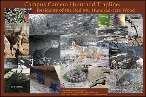
Lauren Hyland, Sara Menne, Meikayla Mixon, Red Mt. Campus Camera Hunt and Trapline: Residents of the Red Mt. Hundred-acre Wood.
2016 Camera Trapping project to capture the campus fauna.
Saguaro Cactus on the Red Mountain Campus
Saguaro Cactus on the Red Mountain Campus
Red Mountain Students for the past 3 years and into the future, Saguaro Cactus on the Red Mountain Campus. This study is recording the location and condition of the Saguaro Cactus on the Mesa Community College Red Mountain campus. The campus is quadrented into 28, 100 meter quadrants. Each semester a team of students records the condition, location and photographs of the cacti in 4 or 5 quadrants on a rotating basis in a database using GIS software. Height, girth, number of arms, condition and a photograph are being recorded over time.